GSMD-500 | Grad Studio 1
Action 3 : Extending and Seeking
My teammate for this Action: Kimia Gholami

Action 3 was talking about extending our studios beyond our usual settings of screen / desk / room. For starters, we were prompt to choose a theoretical construct from the “stretch lexicon” document provided to us. Looking at all those phrases was confusing and overwhelming to choose from but after talking to Kimia, we noticed that we were unconsciously exploring Decolonial design -a hot topic in our dialogue class – so we decided to work together for this action.

Why?
The main idea came from a vintage world map that we’ve been looking at for several years in our studio (where we worked together). This map, because of its vintage colors and overall design, was considered an aesthetically pleasing / decorative object for us. While, it was designed in early 20th century, with outdated political borders and of course showcasing colonialism through out the world. It was only after reading several articles in our class, that this map became unsettling for the first time. Suddenly, it was a VERY colonial map. Not only were the colonized nations color coded, but also the layout of the map was colonial as well. The designer had cut Asia in half only to put north America in the center of it. Not to mention that even the lands were distorted in a way to magnify “White” nations and dismiss other lands such as south America.

1. Action(s):
Recreating Colonialism
We wanted to do something with the map. We thought that maybe in order to investigate Decolonial design, first we should understand colonialism; how it happened and why? We were trying to act like “colonizers” (not a pleasant feeling) and treat the map as they wanted to, in a series of actions.


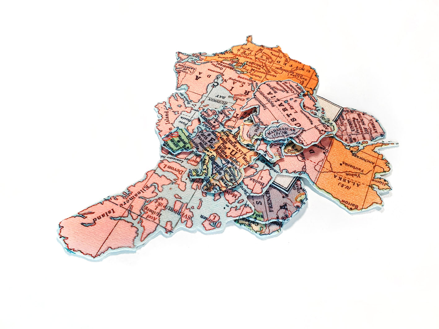
We wanted to get rid of the colors and damage the textures [identity], to our surprise, it wasn’t easy. We had to be forceful, persistent and ended up using several tools. (Burning was an option too but we didn’t risk making a fire) After all, they faded a little bit and the texture was damaged. But in order to make it as white as it gets. We used an opaque white paint and colored over all of them. The colors of the lands however, still peaked through.

We had the white washed lands, but we wanted dominance and authority. Colonizers claimed indigenous lands. Ignoring that they’re in fact intruders from hundreds of kilometers away, so they wanted to eliminate this distance. They couldn’t just extent their borders over their lands, because the weren’t even close to their lands, but somehow they wanted to stitch these lands to their properties, mark them as their own. After rearranging them in different formats [displacement] we decided to sew all of them to Europe and pin them on a cupboard, each pin holding that land and keeping it in place.

We took a moment and looked at the new layout closely. Lands looked almost similar in terms of color although their initial colors were showing still. They were forced to be in these positions. They were displaced. Europe was the center of everything which echoed Eurocentrism in a quite literal manner.

These threads were loose. Moving through history, colonizers couldn’t preserve these ties, many colonial administrations were eliminated. So, we decided to cut them. We were reminded of Grosfoguel’s article (Decolonizing Post-Colonial Studies, 2011), and how he articulated that although “colonialism” almost ended, “global coloniality” continued to thrive in different formats through out the world.
We needed another map!


We cut another map, this time united two halves (!) of Asia, and tried to put everything in an orderly way this time [Emplacement]. We used different pins for different authorizes (and autonomies) but we wanted to showcase the current power paradigms that are still pretty much influenced by Euro/American authorities. We connected the pins together, this time with thiner threads.

This is just a model, definitely unable to show neither the impacts of colonialism or the current power structures. But comparing this and our sewed-whitewashed-maps, we have come a long way.
A world that was once unrecognizable (I’m borrowing this word from Christa (Clay)’s comment on our work in the breakout session) has came a long way and is in the process of Emplacement and healing.
After our intense session of playing around with maps, we decided to have a change of scenery and perspective and get away from our studio. Living in a city with disoriented urban structure and far from nature, we went to the next best thing, which was a small park in the neighborhood.